 Appliances
 Agri Inputs
 Auto Components & Accessories
 Beauty & Personal Care
 Electronics
 Food & Beverages
 Fashion
 Grocery
 Gift Cards
 Home & kitchen
 Health & Wellness
 Vehicles & Automotives
 Books & Stationary
 Toys & Games
 Contact Us
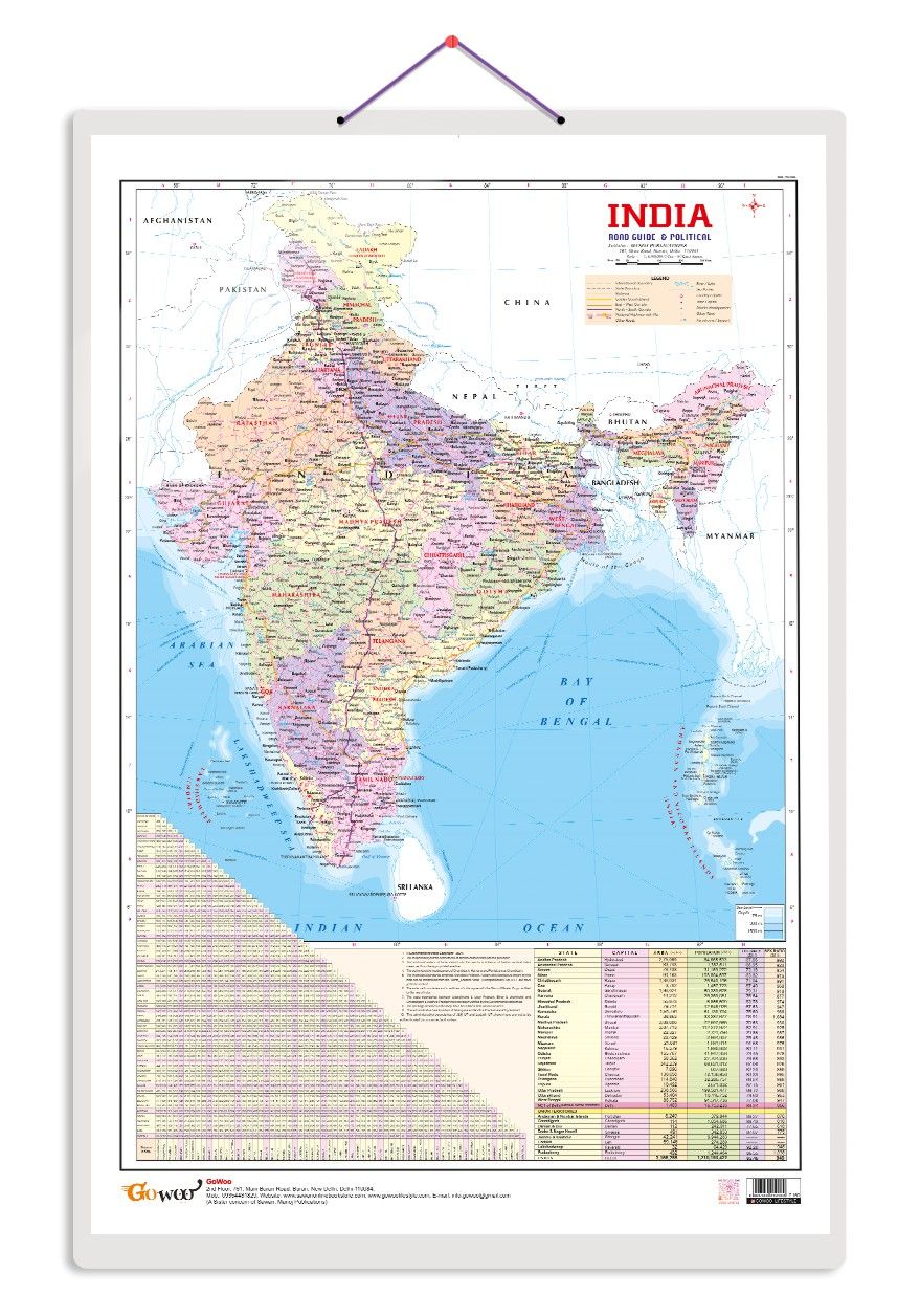
The Indian Road Guide & Political Map chart is a versatile educational resource suitable for various settings, including homeschooling. Measuring 20x30 inches, this durable chart provides valuable information about India's geography and roadways. ...
Read More
Popular Categories
Support
Language
Our apps
Indian Road Guide & Political Map Educational Charts | 20"X30" inch |Non-Tearable and Waterproof | Double Sided Laminated |Useful For Preparation Of SSC, UPSC, RRB, IES, and other exams
The Indian Road Guide & Political Map chart is a versatile educational resource suitable for various settings, including homeschooling. Measuring 20x30 inches, this durable chart provides valuable information about India's geography and roadways.
On one side, the chart displays a detailed political map of India, featuring labelled states, major cities, and boundaries. This site is a comprehensive reference for individuals of all ages interested in understanding India's regional divisions.
The other side of the chart features a road guide, highlighting significant highways, interstates, and essential roadways across the country. This information is valuable for students, travellers, researchers, or anyone seeking to explore and navigate India's road networks.
The chart captures attention and facilitates easy comprehension with its transparent labelling, vibrant colours, and large size. It is an excellent addition to classrooms, offices, or home decor for those passionate about geography and Indian culture.
The Indian Road Guide & Political Map chart offers a valuable resource for anyone interested in exploring India's geography and roadways. Its durability ensures long-lasting use, making it a practical and informative tool for individuals of all ages.
| Country of origin | India |
|---|---|
| Common name | Political Map |
| Net Quantity | 1 unit |
| Manufacturer or packer name | SURAJ SHARMA |
| Manufacturer or packer address | 761 MAIN ROAD BURARI DELHI |
| Manufacturing Date | Oct-95 |
| ISBN | 9788369610 |
| contact details consumer care | GOWOO, [email protected], +919205981829 |


 Early Learning Educational Chart for Kids | 20\"X30\" inch |Non-Tearable and Waterproof | Double Sided Laminated | Perfect for Homeschooling, Kindergarten and Nursery Students")


