
 Appliances
 Agri Inputs
 Auto Components & Accessories
 Beauty & Personal Care
 Food & Beverages
 Electronics
 Fashion
 Grocery
 Gift Cards
 Home & kitchen
 Health & Wellness
 Vehicles & Automotives
 Books & Stationary
 Pet Care
 Toys & Games
 Contact Us

Introducing our "2-in-1 Chhattisgarh Political and Physical Map in English" chart, now available in a convenient 20x30 inch size. This chart is an invaluable resource for students, educators, and anyone interested in exploring the geography of Chh...
Read MorePopular Categories
Support
Language
Our apps
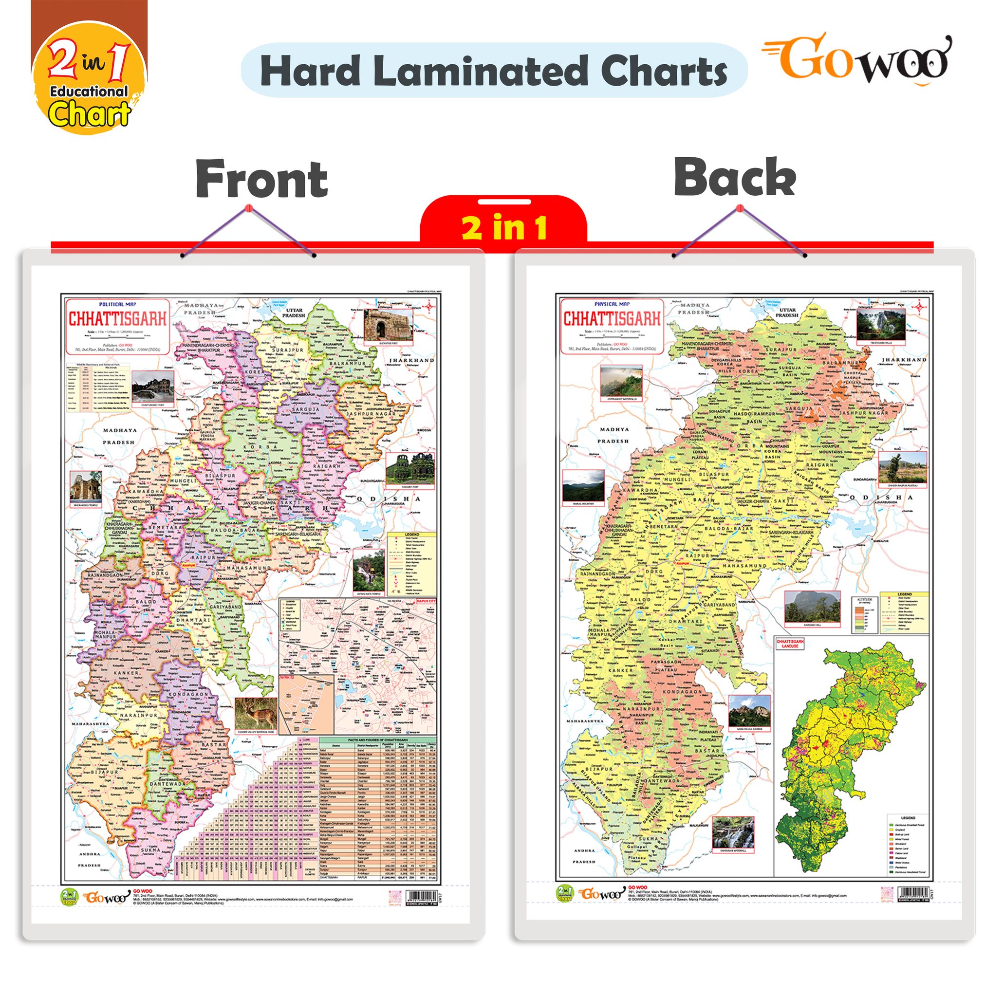
2 IN 1 CHATTISGARH POLITICAL AND PHYSICAL Map IN ENGLISH Educational Charts | 20"X30" inch |Non-Tearable and Waterproof | Double Sided Laminated |Useful For Preparation Of SSC, UPSC, RRB, IES, and other exams
Key Attributes
| Country of origin | India |
|---|---|
| Net Quantity | 1 unit |
| Manufacturer or packer name | SURAJ SHARMA |
Introducing our "2-in-1 Chhattisgarh Political and Physical Map in English" chart, now available in a convenient 20x30 inch size. This chart is an invaluable resource for students, educators, and anyone interested in exploring the geography of Chhattisgarh.
The chart features both a political map and a physical map of Chhattisgarh. The political map showcases the state's administrative boundaries, including districts, capitals, and major cities. It provides a clear overview of the political divisions within Chhattisgarh.
The physical map highlights the state s topography, including mountain ranges, rivers, lakes, and other geographical features. It offers a comprehensive understanding of Chhattisgarh's natural landscape and physical characteristics.
With this 2-in-1 chart, users can easily compare and contrast Chhattisgarh's political and physical aspects. It is a valuable reference tool for studying the state's geography, planning trips or conducting research.
The 20x30-inch size ensures that the details on the map are easily readable and comprehensible. Whether used in a classroom, homeschooling environment, or personal study space, this chart provides a visually appealing and informative representation of Chhattisgarh's political and physical geography.
Explore Chhattisgarh's diverse landscapes and administrative divisions with our "2-in-1 Chhattisgarh Political and Physical Map in English." This chart is essential to your educational resources, enabling a deeper understanding of the state's geography and political structure.
| Country of origin | India |
|---|---|
| Common name | Political Map |
| Net Quantity | 1 unit |
| Manufacturer or packer name | SURAJ SHARMA |
| Manufacturer or packer address | 761 MAIN ROAD BURARI DELHI |
| Manufacturing Date | Oct-95 |
| ISBN | 9788372310 |
| contact details consumer care | GOWOO, [email protected] |


