 Appliances
 Agri Inputs
 Auto Components & Accessories
 Beauty & Personal Care
 Electronics
 Food & Beverages
 Fashion
 Grocery
 Gift Cards
 Home & kitchen
 Health & Wellness
 Vehicles & Automotives
 Books & Stationary
 Toys & Games
 Contact Us

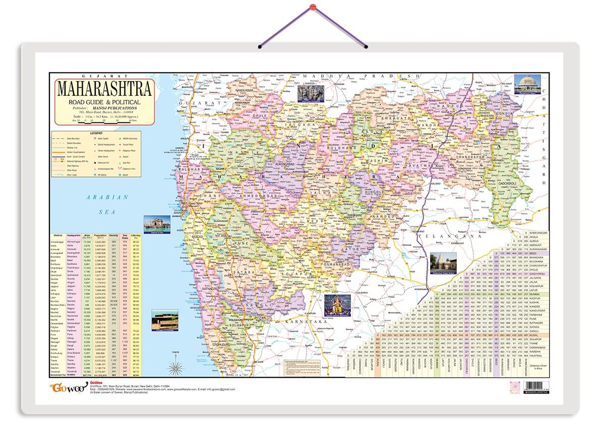
The Maharashtra Road Guide & Political Map is a comprehensive and informative resource focusing specifically on Maharashtra state in India. This map provides detailed information about Maharashtra's road network and political divisions. Featuring ...
Read More
Popular Categories
Support
Language
Our apps
Maharashtra Road Guide & Political Map Educational Charts | 20"X30" inch |Non-Tearable and Waterproof | Double Sided Laminated |Useful For Preparation Of SSC, UPSC, RRB, IES, and other exams
The Maharashtra Road Guide & Political Map is a comprehensive and informative resource focusing specifically on Maharashtra state in India. This map provides detailed information about Maharashtra's road network and political divisions. Featuring a combination of road guides and a political map, this chart offers a wealth of information for travellers, students, researchers, and anyone interested in exploring Maharashtra's geography and transportation infrastructure. The road guide portion highlights significant highways, expressways, and major roadways across Maharashtra, allowing individuals to navigate and plan their journeys effectively. It provides a clear overview of the state's road connectivity and helps in understanding the transportation routes within Maharashtra. The political map section provides a detailed representation of Maharashtra's political divisions, including district boundaries, major cities, and state borders. It offers valuable insights into the state's administrative divisions and geographical features. The Maharashtra Road Guide & Political Map facilitates easy comprehension and enhances spatial understanding with its precise labelling, vibrant colours, and detailed cartography. It is a practical tool for educational institutions, travellers, businesses, and residents of Maharashtra who want to explore and navigate the state efficiently. Whether used in classrooms, offices, or as a reference at home, the Maharashtra Road Guide & Political Map is a reliable and valuable resource for understanding Maharashtra's roadways and political landscape.
| Country of origin | India |
|---|---|
| Common name | Political Map |
| Net Quantity | 1 unit |
| Manufacturer or packer name | SURAJ SHARMA |
| Manufacturer or packer address | 761 MAIN ROAD BURARI DELHI |
| Manufacturing Date | Oct-95 |
| ISBN | 9788369810 |
| contact details consumer care | GOWOO, [email protected], +919205981829 |


 Early Learning Educational Chart for Kids | 20\"X30\" inch |Non-Tearable and Waterproof | Double Sided Laminated | Perfect for Homeschooling, Kindergarten and Nursery Students")


