

Popular Categories
 Appliances
 Agri Inputs
 Auto Components & Accessories
 Beauty & Personal Care
 Electronics
 Food & Beverages
 Fashion
 Grocery
 Gift Cards
 Home & kitchen
 Health & Wellness
 Vehicles & Automotives
 Books & Stationary
 Toys & Games
Support
 Contact Us
Language
Our apps

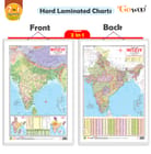
2 IN 1 INDIA POLITICAL AND PHYSICAL MAP IN HINDI Educational Charts | 20"X30" inch |Non-Tearable and Waterproof | Double Sided Laminated |Useful For Preparation Of SSC, UPSC, RRB, IES, and other exams
1 unit
₹179
MRP ₹180
Sold By:GOWOO
| Country of origin | India |
|---|---|
| Common name | Political and Physical Map |
| Net Quantity | 1 unit |
| Manufacturer or packer name | SURAJ SHARMA |
| Manufacturer or packer address | 761 MAIN ROAD BURARI DELHI |
| Manufacturing Date | Oct-95 |
| ISBN | 9788372710 |
| contact details consumer care | GOWOO, [email protected], +919205981829 |
We are introducing our "2-in-1 Indian Political and Physical Map" chart in Hindi. This chart is available in 20x30 inches and provides a comprehensive overview of India's political and physical features. The chart consists of two sections: the political and physical maps. The political map displays the boundaries of states, union territories, and major cities of India. It clearly represents India's political divisions and helps users understand the country s administrative structure. The physical map showcases the geographic features of India, including mountain ranges, rivers, lakes, and coastal regions. It visually depicts India's diverse physical landscape and highlights the country's natural wonders. This 2-in-1 chart is a valuable resource for students, teachers, researchers, and anyone interested in exploring India s political and physical aspects. It is printed on high-quality material to ensure durability and clarity of information. Whether for educational purposes, homeschooling, or personal reference, this chart is valuable for enhancing geographic knowledge and understanding of India. Its large size makes it easily readable and suitable for display in classrooms, offices, or home study areas.

Sold By
GOWOO
Not Cancellable
Not Returnable


